
Maze 220m south east of St Peter and St Paul’s Church, Wing
Overview
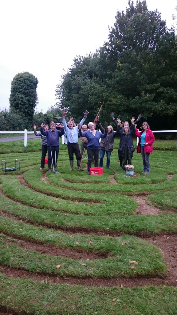
We are the proud hosts of a rare historical artefact – The Wing Maze. It is one of only 8 surviving examples in the country. We are starting a new campaign to formalise the care and upkeep of this rare and significant part of our history.
From English Heritage
Heritage Category:Scheduled Monument
List Entry Number:1019306
Date first listed:07-Nov-1938
Date of most recent amendment:07-Jun-2000
Map
© British Crown and SeaZone Solutions Limited 2019. All rights reserved. Licence number 102006.006.
Use of this data is subject to Terms and Conditions.
The above map is for quick reference purposes only and may not be to scale.
This copy shows the entry on 27-Aug-2019 at 12:47:51.
Location
The building or site itself may lie within the boundary of more than one authority.
District:Rutland (Unitary Authority)
Parish:Wing
National Grid Reference:SK 89545 02835
Reasons for Designation
Mazes have a long lived history and have a variety of form and purpose, most commonly as garden features. They are thought by some to derive from prehistoric cup and ring marked stones and other megalithic sculpture with spiral designs, several examples of which are found in the British Isles. The earliest recognized maze design is the seven ring classical or Cretan labyrinth, single pathed and found as designs carved on stone, cut into turf or marked by boulders. Mazes also exist as designs on Roman produced mosaic pavements; and six are known to be in Britain. The medieval Church adopted a new design of maze, the earliest known full sized example being the pavement maze in Chartres Cathedral laid out in 1235. These medieval Christian mazes are circular or octagonal, with a single path following 11 concentric rings and forming an overall cruciform design, probably meant to be used as a penance, completed on the knees to gain forgiveness for sins. More secular uses of mazes continued until at least the 18th century, although between 1649 and 1659 maze games were one of the activities either discouraged or outlawed by the Puritan dominated Republic. The first more complicated puzzle mazes developed from the 15th century as features of ornamental gardens, with paths separated by hedges or flower borders, the most famous being the Hampton Court maze which was laid out in 1689-96. In the 19th century there was a revival of interest in mazes of all designs which continued into the 20th century. It is thought that there were over 100 medieval turf cut mazes in England of which the approximate locations of 60 are known. Of these, less than eight are believed to survive in their original locations. A number of other maze types are also known, including small finger mazes carved on natural rock walls in Cornwall, and at least one boulder maze on the Isles of Scilly. Mazes are a rare monument type, providing an unusual insight into early social, recreational, religious and ritual activity. All examples still in their original position and with a documented antiquity are likely to be nationally important.
The maze 220m south east of St Peter and St Paul’s Church survives well and is a rare example of a once more common monument class. As part of a more widespread tradition, its complex pattern has continental parallels providing an insight into artistic and religious links between Europe and England. The survival of the maze as a public monument to the present day demonstrates its continuing importance as an amenity to both the local populace and to the wider public.
Details
The monument includes the buried and earthwork remains of a medieval turf maze 220m south east of St Peter and St Paul’s Church. The maze is circular and measures approximately 14m in diameter. A single path forms an 11 ring, cruciform pattern which is typical of medieval church mazes and similar to that in Chartres Cathedral. It is also believed that the pattern is similar to that at the church of Santa Maria in Aquino at Rome. The maze path is cut into the turf approximately 5cm to 10cm deep and is 22cm to 45cm wide. It is gravel filled, and it has been suggested that it may have had an external bank although no trace of this is evident. The timber fence and interpretation board are excluded from the scheduling, although the ground beneath them is included.
MAP EXTRACT The site of the monument is shown on the attached map extract. It includes a 3 metre boundary around the archaeological features, considered to be essential for the monument’s support and preservation.
Legacy
The contents of this record have been generated from a legacy data system.
Legacy System number:31972
Legacy System:RSM
Sources
Books and journals
Hartley, R F, The Medieval Earthworks of Rutland, (1983), 48
Pevsner, N, Williamson, E, The Buildings of England: Leicestershire and Rutland, (1984), 522
‘Archaeological Journal’ in Wing, turf maze, (1858)
Trollope, E, ‘Archaeological Journal’ in Notices of ancient and medieval labyrinths, , Vol. XV, (1858), 217-235
Legal
This monument is scheduled under the Ancient Monuments and Archaeological Areas Act 1979 as amended as it appears to the Secretary of State to be of national importance. This entry is a copy, the original is held by the Department for Digital, Culture, Media and Sport.

You must be logged in to post a comment.